


Updated November 5, 2026 · SAMHSA data
How far is treatment from each Ohio county?
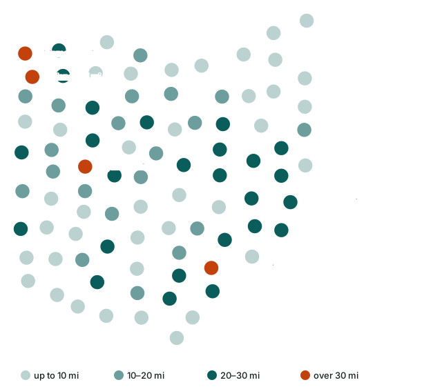
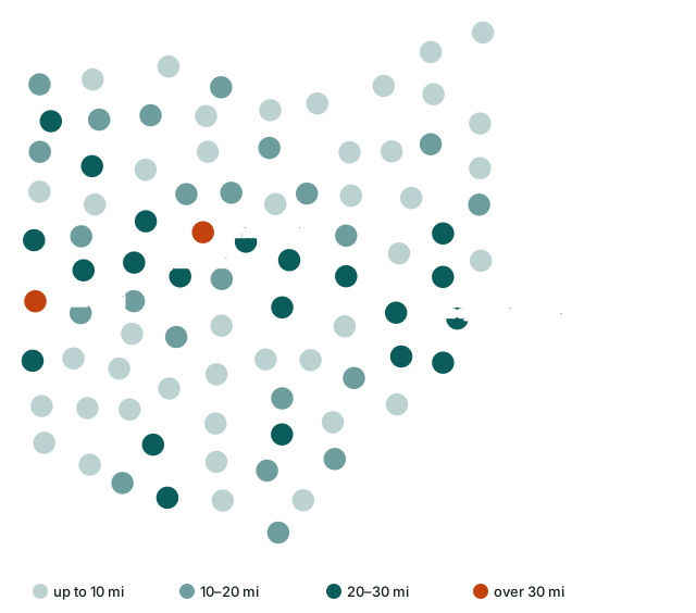
We measured the distance from the center of every one of Ohio's 88 counties to the nearest listed detox, residential program and medication clinic. In 4 counties home to 184,501 people, the nearest detox is more than 30 miles away, and 2 counties (Noble County, Wyandot County) have no addiction treatment facility of their own.
Have the insurance card and ZIP code ready, yours or a loved one's. Paid referral line, answered by a partner, not by a program listed here.
All 88 counties
Sorted by distance to the nearest detox. Miles are straight-line, so driving distance is longer.
| County | Population 2024 | Facilities in county | Detox, mi | Residential, mi | MAT, mi |
|---|---|---|---|---|---|
| Williams County | 36,554 | 1 | 45.6 | 14.5 | 6.2 |
| Athens County | 63,218 | 9 | 33.0 | 2.1 | 2.1 |
| Defiance County | 38,644 | 2 | 30.8 | 23.7 | 6.8 |
| Logan County | 46,085 | 2 | 30.2 | 29.4 | 2.4 |
| Belmont County | 64,692 | 5 | 28.4 | 28.4 | 12.5 |
| Monroe County | 13,051 | 1 | 28.4 | 26.6 | 26.6 |
| Guernsey County | 38,219 | 5 | 27.7 | 28.1 | 5.1 |
| Highland County | 43,785 | 1 | 27.5 | 21.7 | 22.0 |
| Vinton County | 12,545 | 1 | 27.0 | 20.2 | 16.8 |
| Hancock County | 75,016 | 4 | 26.7 | 5.2 | 4.3 |
| Fayette County | 28,782 | 1 | 26.4 | 1.5 | 21.4 |
| Jackson County | 32,723 | 4 | 26.4 | 17.3 | 1.3 |
| Holmes County | 44,668 | 1 | 26.2 | 16.2 | 16.2 |
| Hardin County | 30,402 | 1 | 25.3 | 23.5 | 21.9 |
| Morgan County | 13,532 | 1 | 25.1 | 19.5 | 22.6 |
| Carroll County | 26,460 | 1 | 24.6 | 20.5 | 19.7 |
| Noble County | 14,269 | 0 | 24.5 | 21.3 | 19.2 |
| Mercer County | 42,648 | 1 | 24.2 | 24.2 | 22.1 |
| Union County | 71,721 | 1 | 23.7 | 24.1 | 21.2 |
| Coshocton County | 37,003 | 2 | 22.9 | 22.7 | 4.0 |
| Knox County | 63,848 | 3 | 22.7 | 23.5 | 22.7 |
| Preble County | 40,801 | 3 | 22.7 | 20.8 | 20.8 |
| Harrison County | 14,042 | 1 | 22.5 | 22.5 | 22.5 |
| Henry County | 27,536 | 1 | 22.1 | 14.7 | 5.1 |
| Tuscarawas County | 92,048 | 7 | 22.1 | 5.2 | 4.1 |
| Fulton County | 42,028 | 3 | 21.7 | 4.1 | 12.6 |
| Meigs County | 21,491 | 2 | 21.0 | 15.5 | 14.9 |
| Wayne County | 116,632 | 5 | 20.5 | 2.9 | 2.9 |
| Crawford County | 41,626 | 1 | 20.3 | 16.8 | 20.3 |
| Medina County | 184,625 | 5 | 20.0 | 9.9 | 3.0 |
| Huron County | 58,168 | 5 | 19.9 | 19.9 | 7.8 |
| Clinton County | 42,019 | 5 | 19.7 | 2.4 | 2.7 |
| Wyandot County | 21,394 | 0 | 19.3 | 19.0 | 19.3 |
| Pike County | 27,065 | 8 | 18.6 | 4.4 | 4.1 |
| Perry County | 35,682 | 5 | 18.5 | 2.3 | 15.0 |
| Darke County | 51,462 | 1 | 18.3 | 31.0 | 2.2 |
| Putnam County | 34,206 | 1 | 18.3 | 20.6 | 18.3 |
| Morrow County | 35,927 | 3 | 17.9 | 20.3 | 17.1 |
| Hocking County | 27,429 | 2 | 17.1 | 16.3 | 16.0 |
| Paulding County | 18,755 | 1 | 16.9 | 16.9 | 1.0 |
| Madison County | 45,531 | 2 | 16.0 | 17.3 | 2.8 |
| Ottawa County | 39,692 | 1 | 15.5 | 15.5 | 15.5 |
| Ashland County | 52,420 | 4 | 15.1 | 12.3 | 14.2 |
| Columbiana County | 99,823 | 12 | 14.8 | 18.4 | 1.0 |
| Auglaize County | 45,922 | 1 | 14.6 | 13.1 | 12.0 |
| Shelby County | 47,952 | 1 | 13.6 | 27.5 | 2.9 |
| Delaware County | 237,966 | 6 | 13.3 | 10.7 | 9.9 |
| Champaign County | 38,907 | 1 | 12.6 | 12.6 | 2.6 |
| Seneca County | 54,730 | 6 | 10.7 | 4.8 | 2.7 |
| Lawrence County | 55,829 | 12 | 9.9 | 13.1 | 9.9 |
| Lake County | 232,360 | 11 | 9.3 | 3.5 | 3.5 |
| Pickaway County | 62,158 | 4 | 8.2 | 6.5 | 6.4 |
| Sandusky County | 58,866 | 2 | 7.9 | 7.9 | 7.9 |
| Warren County | 256,059 | 9 | 7.4 | 9.3 | 2.0 |
| Mahoning County | 225,786 | 26 | 7.1 | 6.3 | 6.2 |
| Miami County | 111,950 | 4 | 7.0 | 16.3 | 6.4 |
| Portage County | 163,839 | 13 | 6.6 | 17.3 | 2.6 |
| Geauga County | 95,362 | 9 | 6.1 | 1.0 | 6.1 |
| Trumbull County | 200,300 | 17 | 5.8 | 5.8 | 5.0 |
| Erie County | 73,841 | 7 | 5.7 | 6.8 | 5.7 |
| Gallia County | 28,886 | 7 | 5.7 | 2.9 | 2.8 |
| Adams County | 27,671 | 1 | 5.5 | 24.6 | 5.5 |
| Stark County | 374,091 | 29 | 5.4 | 1.8 | 1.0 |
| Jefferson County | 63,900 | 6 | 5.3 | 5.3 | 5.3 |
| Brown County | 44,292 | 5 | 5.2 | 18.1 | 5.2 |
| Montgomery County | 537,443 | 43 | 4.8 | 2.0 | 2.0 |
| Lucas County | 426,291 | 23 | 4.5 | 3.8 | 3.7 |
| Ross County | 76,046 | 12 | 4.4 | 4.7 | 3.2 |
| Scioto County | 71,798 | 12 | 4.2 | 1.5 | 4.2 |
| Washington County | 58,332 | 11 | 3.9 | 2.2 | 2.2 |
| Cuyahoga County | 1,240,594 | 57 | 3.6 | 2.5 | 1.5 |
| Ashtabula County | 96,906 | 10 | 3.5 | 1.6 | 1.6 |
| Muskingum County | 86,582 | 6 | 3.5 | 4.0 | 2.6 |
| Butler County | 399,542 | 28 | 3.4 | 3.6 | 2.8 |
| Van Wert County | 28,887 | 3 | 3.2 | 3.2 | 0.4 |
| Licking County | 184,898 | 8 | 3.1 | 21.7 | 3.1 |
| Fairfield County | 167,762 | 10 | 2.2 | 3.1 | 2.2 |
| Hamilton County | 837,359 | 42 | 2.2 | 1.5 | 2.2 |
| Wood County | 133,077 | 3 | 2.2 | 16.1 | 2.2 |
| Marion County | 64,976 | 10 | 2.1 | 33.4 | 2.1 |
| Clermont County | 214,123 | 10 | 1.9 | 2.0 | 1.9 |
| Greene County | 172,347 | 8 | 1.9 | 2.3 | 1.9 |
| Lorain County | 322,030 | 13 | 1.9 | 1.2 | 1.9 |
| Summit County | 538,370 | 33 | 1.9 | 1.9 | 1.4 |
| Allen County | 100,866 | 7 | 1.5 | 3.1 | 1.5 |
| Richland County | 124,853 | 9 | 1.1 | 2.8 | 1.1 |
| Franklin County | 1,356,303 | 78 | 1.0 | 2.5 | 0.5 |
| Clark County | 134,985 | 8 | 0.8 | 0.8 | 0.8 |
Not sure where to start?
Not sure which program fits? You can also call the referral line below, or contact any listed program directly.
Paid referral line, answered by a partner, not by a program listed here.
Method
Facilities: SAMHSA FindTreatment.gov, every Ohio listing that reports substance use treatment or detox, snapshot November 5, 2026. County centers: U.S. Census Bureau 2024 Gazetteer. Population: Census 2024 estimates. A facility is placed in a county by its ZIP code (Census ZCTA to county file). Distances are great-circle miles from the county's internal point to the facility's listed coordinates; listings without coordinates in SAMHSA are placed by the Census Geocoder from their address, or at their ZIP code center when no street is published. Certified opioid treatment programs (OTP) count as MAT. Data can be reused with a link to this page.